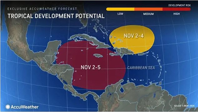
Storm Patty is brewing in the Caribbean – and there’s a good chance it hits the US.
AccuWeather meteorologists are monitoring a disturbance that could strengthen as it moves into the central or west where conditions are optimal for development.
Lead hurricane expert Alex DaSilva, said: ‘Next week, most of the wind shear will shift to the north, and so it will basically create a pocket with high ocean temperatures, plenty of moisture and very low wind shear that will be favorable for tropical development.’
There are two potential paths this storm could take: one to the west and the other to the north.
The western track is unlikely to impact the US, but it could hit South Florida if the storm gains momentum in the next seven days.
‘Storms in the Caribbean usually move to the north or northeast in November. This means that residents and visitors from Florida (including the Gulf Coast) to the Carolinas will have to keep a close eye on development,’ DaSilva said.
This has prompted the National Hurricane Center (NHC) to slightly increase the chances of a tropical disturbance forming in the next seven days.

AccuWeather meteorologists say there is a 90 percent chance that hurricane will form in the Caribbean this weekend or early next week, potentially hitting the US
DaSilva added: ‘Even if a tropical storm forms and tracks into Mexico or Central America, changing steering winds can turn that storm to the northeast and toward Florida later on. ‘
But regardless of whether a hurricane forms, the Caribbean islands can expect rough seas and heavy rain next week as this system rolls in.
This storm has been slow to organize due to high wind shear in the area.
‘It has created a very hostile environment for showers and thunderstorms to organize into a tropical threat. There is not a lot of dry air in place, so it’s really just the wind shear that has been holding things back,’ explained DaSilva.
But that wind shear is expected to shift next week, creating a ‘pocket’ of favorable conditions for hurricane development.
If this storm begins to organize, it will do so slowly, according to meteorologists.
This is typical for storms that develop in the Central American Gyre, a large, bloated area of low-pressure can be an early and late-season source of tropical development, according to The Weather Channel.
But if and when it does become a hurricane, it could rapidly strengthen.

There are two potential paths this storm could take: one to the west and the other to the north. If the storm tracks north, it could hit South Florida
Hurricane Oscar was an example of this. This system rapidly intensified from a tropical storm to a hurricane in a matter of hours.
As for when exactly Hurricane Patty could hit South Florida, experts say it’s too early to tell.
AccuWeather will be able to give an updated forecast on the direction and potential landfall of this storm if and when it develops.
If it does track toward the sunshine state, residents will have to brace for their fourth named storm since August.
Hurricane Patty would come on the heels of Hurricanes Debby, Helene and Milton, which made landfall in Florida in August, September and October, respectively.
The state is still reeling from the devastation caused by Milton, which hit just two weeks after Helene.
This Category 3 storm battered Florida with over 100 mph winds, up to 18 inches of rain and devastating flood surge.
It also whipped up 150 tornado warnings throughout the state and left more than three million homes and businesses without power.
Officials estimate that the storm caused $50 billion worth of damage and claimed the lives of at least 14 people.
Milton was the fifth hurricane to make landfall in the Gulf Coast this season, and the 13th named storm overall.
While the Atlantic hurricane season is drawing to an end, AccuWeather meteorologists have warned that up to three more named storms could form before it officially concludes on November 30.
There are low risks of direct impacts along the Gulf Coast through Alabama, with a possible path to Florida and up the East Coast.
‘We may even see a tropical storm in December this year. It doesn’t happen very often, but the very warm sea surface temperatures could make it possible this year,’ DaSilva previously said.
This article was originally published by a www.dailymail.co.uk . Read the Original article here. .


