Forecasters have warned that the Atlantic Ocean has not tapped out of the hurricane season just yet.
The latest predictions suggested there could be up to three named storms before November 30, when storm season typically ends, due to unusually warm ocean temperatures.
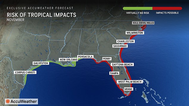
There are low risks of direct impacts along the Gulf Coast through Alabama, with a possible path to Florida and up the East Coast.
AccuWeather lead hurricane expert Alex DaSilva said: ‘We may even see a tropical storm in December this year. It doesn’t happen very often, but the very warm sea surface temperatures could make it possible this year.’
November produces only one Atlantic hurricane every one to two years, with just seven occurring in December since 1851.
‘We’ve been saying since March that the end of this year’s hurricane season could be quite active,’ said DaSilva.
Any late-season tropical storms that hit the US are more likely to affect Florida and the East Coast, the meteorologist continued, as this region recovers from the devastation of Hurricane Helene and Hurricane Milton.
‘The entire state of Florida up into the Carolinas could be at risk of experiencing another tropical impact this season,’ DaSilva said.

Any late-season tropical storms that hit the US are more likely to affect Florida and the East Coast, the meteorologist continued, as this region recovers from the devastation of Hurricane Helene and Hurricane Milton
‘This region is already vulnerable after dealing with multiple landfalls earlier this year.
‘The western and central Gulf of Mexico coastline likely will not see any direct impacts for the rest of this hurricane season.’
Helene and Milton left these states highly vulnerable to another storm as residents pick up the pieces of their homes and communities.
Piles of debris, downed powerlines and damaged infrastructure can become projectiles in the event that storm surge and high winds barrel into an already hurricane-battered state.
And destruction to homes and community buildings can leave people without adequate shelter when the storm hits.
Florida officials estimate that the total damage and economic loss from Hurricane Milton is between $160 billion and $180 billion.
In North Carolina, officials estimate Hurricane Helene caused roughly $53 billion of damage.
A named storm could form in the Atlantic basin as soon as next week, according to AccuWeather Chief On-Air Meteorologist Bernie Rayno.
‘There is a large area of high-pressure building across the northeast that has sent a stalled front southward,’ he said in a statement.
‘That sets off a chain reaction that begins with showers and thunderstorms in the southern Caribbean.’

Hurricane trackers predicted up to three more storms could form in the Atlantic, which could take a similar path as Milton (pictured)
DaSilva said families, businesses, emergency officials and government leaders in the Caribbean islands should be on alert for the potential of tropical impacts in early November.
‘We’re already starting to see the early signs of development with showers and thunderstorms developing in the southern Caribbean,’ he continued.
‘As the area of high pressure builds to the north, it’s going to create a very favorable environment for intensification.
‘This could lead to a tropical storm or even a hurricane in the first few days of November.
‘We expect very little wind shear, and the water temperatures are exceptionally warm for this time of year.’
Experts have determined two likely scenarios that could happen if a storm develops with the next week.
‘Climatology favors a more north or northeast track for storms that develop in this region in November,’ explained DaSilva.
‘If a storm develops, it could move across Cuba or Hispaniola and move out into the open Atlantic, but we do have to watch for the possibility of eventual impacts to Florida.
‘The area of high pressure could potentially block a storm from heading out to sea and essentially force the storm to turn west toward Florida.’
The second scenario is a western track that would use a high pressure area to move west into the Yucatan Peninsula.
‘If the area of high pressure starts to weaken, it could allow the storm to turn to the north,’ said DaSilva.
‘There are a lot of moving pieces to this puzzle. If a storm develops, the eventual path hinges on how strong the area of high pressure will be to the north.’
This article was originally published by a www.dailymail.co.uk . Read the Original article here. .


