Hurricane watchers have issued a warning for the final month of the season after predictions showed another storm could hit Florida.
The season is set to conclude on November 30, but the Atlantic Ocean is still showing signs that are favorable for cyclones.
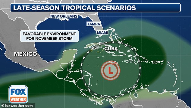
Meteorologists predicted a tropical storm could form in an area of high pressure that would push it on the same path as Helene and Milton that struck Florida earlier this month.
The pressure system could also create a funnel, allowing it to travel up the Eastern Seaboard.
Meteorologist Michael Lowry told USA Today: ‘Named storms affecting us here in the states in November only happen about once every 15 years on average.
‘They’re an uncommon occurrence but when they do strike, they almost invariably strike Florida.’
While rare, the Sunshine State has seen three hurricanes in November since 2005, with the most recent in 2022.

Meteorologists warn that there are three possible scenarios that could bring tropical storms and hurricanes to the central Atlantic from next week through early November
AccuWeather forecasters are predicting that there’s is a medium chance that a tropical depression or tropical storm could brew over the Atlantic by the end of next week.
While weather experts keep a watchful eye on Florida, they have identified two other scenarios that would shield the US from future storms.
All three predictions are possible due to the Central American Gyre, which is a large, seasonal area of low pressure that can last for two weeks and trigger a formation of tropical storms and hurricanes.
‘At the very end of the month now, we get this low pressure that starts to form eerily similar to that Central America Gyre,’ FOX Weather Meteorologist Steve Bender said.
‘But this one is right over the heart of the Caribbean. So you’ve got all this tropical moisture that’s going to be able to get tapped into.’

The first scenario could bring high pressure that would prevent growing storms from reaching the US
Scenario 1: High pressure prevents storms from reaching the US
Forecasters explained that the first possible outcome of a tropical formation would be high pressure acting as a barricade to protect the US from developing storms.
If strong high pressure, also known as a wind shear, remains in place over the southeastern US it could stop any storms from reaching the coast.
Wind shears can stop storms by removing heat and moisture from the air which is needed for a tropical storm or hurricane to develop.

The second possibility would force any tropical storms to take the same path as Oscar and head for Cuba and the Greater Antilles
Scenario 2: Storm takes Tropical Storm Oscar’s path
The second scenario is similar to the first possibility, with the exception that the high pressure would be centered over Texas.
If this happened, the US would still be protected from any tropical storms but a jet stream across the Atlantic would force storms eastward toward Cuba and Greater Antilles.
This would ultimately be the same path taken by Hurricane Oscar last week which brought up to 20 inches of rain to the region and caused flash flooding and mudslides.

The final scenario could bring major storms to Florida which is still recovering from being battered by Hurricanes Helene and Milton
Scenario 3: High pressure causes storms to reach Florida
The final scenario would be the worst case for the US as high pressure would build up over the central Atlantic.
High air pressure forms over the Atlantic when the air cools enough to release drier air from the atmosphere.
When this develops over the center of a storm, it removes the heat from the air rising through the eye and drives its growth.
The air is then sucked into the storm’s center which increases wind speeds and causes it to become a tropical storm once it reaches 39 miles per hour.
Wind speeds that exceed 75 miles per hour will result in the storm being upgraded to a hurricane.
The high-pressure ridge, as shown in this scenario, is what steered Hurricane Helene and Milton toward the Gulf Coast before they reached the eastern US coast.
The Central American Gyre also created an area of low pressure in the western Caribbean – where Helene originated – which combined with the Gulf of Mexico’s unusually warm atmosphere, causing the storm to rapidly intensify.
‘You are looking at two high pressures that are kind of funneling (any storms) along the East Coast,’ Bender told Fox.
‘And as it tracks, then you could start to see those impacts areas that have already felt massive impacts’ from Hurricane Helene.
This article was originally published by a www.dailymail.co.uk . Read the Original article here. .


