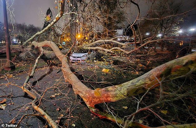
A bomb cyclone wreaked havoc as it tore through the Washington on Tuesday, hospitalizing one person and leaving hundreds of thousands of residents without power.
The cyclone, which is being called a ‘once in a decade’ event, is currently located 300 miles off the Washington coast, but reached the state around 7pm PT.
Wind gusts reached over 70 miles per hour overnight, downing trees and power lines across Seattle which blocked multiple main highways and crashed into homes and vehicles.
‘Trees are coming down all over the city & falling onto homes,’ Bellevue Fire officials warned Washington residents.
‘If you can, go to the lowest floor and stay away from windows. Do not go outside if you can avoid it.’
The Seattle Fire Department responded to reports that a tree crashed through a car’s windshield late Tuesday night, trapping the driver inside the vehicle.
The first responders were able to extricate the patient who was rushed to a nearby hospital and remains in stable condition.
In the wake of the cyclone, the downed power lines caused more than 700,000 residents to lose power, but roughly 130,000 customers’ electricity was restored as of as of Wednesday at 8:40am PT, according to poweroutage.us.

Washington residents experienced major power outages after a bomb cyclone downed trees and power lines (pictured) throughout the western part of the state on Tuesday

AccuWeather meteorologists predicted that the area will still see severe wind gusts and rainfall reaching up to 20 inches through the end of the week
‘There are so many trees and power lines down, we would be posting the locations till the lights turn on,’ the Snohomish Regional Fire & Rescue posted on X.
The National Oceanic and Atmospheric administration (NOAA) reported that the outages affected its radio transmissions at its Seattle office at about 10:30pm PT and the agency said it didn’t ‘have an estimation as to when they will be back on the air.’
It remains unclear when power will be fully restored to Washington residents.
Western Oregon also felt the impact of the bomb cyclone, with wind gusts reaching 30 to 50 miles per hour, while parts of northern California experienced gusts reaching up to 80 miles per hour.
The bomb cyclone was fueled by a low pressure center caused by an atmospheric river that propelled its development within mere hours.
An atmospheric river is a long stream of moisture in the atmosphere that carries large amounts of water vapor and can produce extreme amounts of snowfall or rain when it moves over land.
AccuWeather meteorologists predicted that the Washington area will still see severe rainfall that can reach up to 20 inches through Friday.
Dangerous wind gusts are expected to continue into Wednesday evening and will bring heavy rainfall to parts of the state and northern California throughout the week.
A buoy off the coast of Vancouver Island recorded wind gusts exceeding 100 miles per hour on Tuesday night, while the Oregon National Weather Service (NWS) also reported that this storm was the most intense ever recorded in that region of the Pacific Ocean.
The storm’s central air pressure reached 943 millibars on Tuesday, putting it on par with that of a Category 4 hurricane.
However, it earned the qualification of a bomb cyclone because it strengthened to about 24 millibars in under 24 hours.

The bomb cyclone is expected to continue to bring severe rainfall and heavy wind gusts to Washington, California and Oregon through the end of the week

More than 700,000 people were left without power when the bomb cyclone hit

Trees crashed through homes (pictured) and left one woman dead after it landed on a homeless encampment

The bomb cyclone accelerated to wind speeds topping 100 miles per hour in the Pacific Ocean, propelled by an atmospheric river that helped it form within 24 hours
Meteorologists reported that the storm will result in flooding as it brings one to five inches of rain to western Oregon and Washington within the next four days.
Dangerous rock slides and debris flows are also expected to hit the area through the week, according to the NWS Weather Prediction Center.
A winter storm watch has also been issued for the northern Sierra Nevada which could see up to 15 inches of snow and wind gusts topping 75 miles per hour in mountainous areas.
People took to social media to document the effects of the bomb cyclone, with one X user posting: ‘Holy sh** it’s bad outside.
‘Went out to check on things while the rain stopped. Now the winds shifted and got stronger.’
Another wrote: ‘Well… a giant tree just ripped it’s roots out and came down in my yard. Very very lucky with where it fell. A different direction or a few feet over and it would have been very very bad.’
This article was originally published by a www.dailymail.co.uk . Read the Original article here. .


