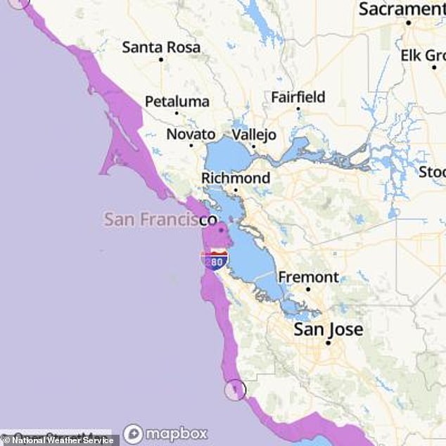
Deadly 16-foot-waves are expected to hit the beaches of Northern California, triggering officials to issue a ‘stay of of water’ warning.
The National Weather Service (NWS) released the alert Tuesday, saying strong strong offshore winds will cause ‘dangerous swimming and surfing conditions and localized beach erosion.’
The weather advisory is in effect until 6am PT Wednesday for beaches across San Francisco, northern and southern Monterey Bay and Big Sur counties.
Deep water waves in the area are typically 10 feet high this month, but NWS Meteorologist Dylan Flynn reported that they could surpass 17 feet.
Even the most experienced swimmers have been warned to stay out of the water because the large waves can create a strong undercurrent that will pull people into the sea.
Those visiting northwest-facing beaches are the most at risk of being pulled under the water and are also advised to keep their pets away from the beach shore.
An atmospheric river that formed off the coast of California on Sunday was behind the high waves, but meteorologists said it took 24 hours for them to reach the shore.
The strong wind gusts could hit speeds of 50 to 60 miles per hour over the ocean and although the wind won’t reach the coast, the resulting waves still pose a major threat.

San Francisco beachgoers were warned to stay out of the water as 16-foot high waves crash against the shore
‘Dangerous swimming and surfing conditions and localized beach erosion. Large waves can sweep across the beach without warning, pulling people into the sea from rocks, jetties and beaches,’ the NWS stated.
‘Sudden immersion in cold water can result in cold water shock even for the most experienced swimmers.
‘Cold water shock can result in dramatic changes in breathing, heart rate and blood pressure, greatly increasing the risk of drowning in rough open waters.’
The agency also noted that northwest-facing beaches are at a high risk for large turbulent shore breaks and strong currents.
Although the NWS warning is in place until Wednesday morning, Flynn told Newsweek that another advisory will likely be issued through Thursday.
The deep water waves were caused by a storm force low pressure system which forms when low pressure associated with thunderstorms and hurricanes builds in the atmosphere.
The low pressure at the storm’s center causes wind speeds to reach 38 miles per hour and forces the air to rise into the atmosphere, significantly increasing the size and intensity of waves in the ocean.

Even the most experienced swimmers have been warned to stay out of the water because the large waves can create a strong undercurrent that will pull people into the sea (stock)
Deep water waves only occur in ocean depths at least twice their wavelength, meaning if the wave is 17 feet above the ocean’s surface it formed where the ocean’s depth was greater than 34 feet.
When these waves approach the shoreline and enter shallow water, they can increase height by 200 percent – a phenomenon known as shoaling.
This is where the wave’s energy becomes more concentrated as its speed decreases which causes the wavelength to shorten and its height to increase, leading to larger breaking waves.
California has experienced an increase in atmospheric rivers in the last few years, with meteorologists reporting the state was hit by nine within just three weeks between December 2022 and January 2023.
Atmospheric rivers are relatively long and narrow regions that carry water vapor outside of the tropics.
They can extend up to 1,000 miles in length, and back-to-back atmospheric rivers, also called AR families, can trigger significantly heavy flooding.
‘These start over warm water, typically tropical oceans, and are guided toward the coast by low-level jet streams ahead of cold fronts of extratropical cyclones,’ Qian Cao, a hydrologist at the University of California, San Diego told PBS.
The first bout of heavy rainfall drenches the ground and prevents the soil from absorbing more liquid, causing water levels to build up and sea levels to rise.
This weather phenomenon typically happens when large scale weather patterns sync up to form narrow stretches of intense moisture transport.
They can happen anywhere in the world but primarily occur in the mid-latitudes regions – roughly 30 to 60 degrees north or south of the equator.
This article was originally published by a www.dailymail.co.uk . Read the Original article here. .


